 Safekipedia
Geography of Pluto
Adapted from Wikipedia · Adventurer experience
Pluto is a small, faraway world that goes around our Sun. It used to be called the ninth planet, but now it is known as a dwarf planet. Scientists study Pluto to learn about objects in the outer solar system and how they were made.
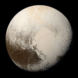
On 14 July 2015, a special spacecraft named New Horizons became the first to fly by Pluto. During its quick visit, New Horizons took many pictures and gathered important information. These pictures showed Pluto has many different landscapes, like mountains, flat areas, and dark spots.
The geography of Pluto helps us learn what this faraway world is like. By mapping its surface, scientists can see how Pluto changes and how it is similar to or different from other objects in space. The information from New Horizons has helped us learn more about Pluto and its moons.
Coordinate system orientation
Further information: Poles of astronomical bodies
Pluto can spin in two different ways. Scientists use one way where the north side is mostly lit by the sun and the south side is dark. This is how the International Astronomical Union (IAU) and the New Horizons team make their maps, with the lit side at the top. Older books might describe Pluto’s spin differently. The directions east and west can look different depending on how you describe Pluto’s spin.
The main line of longitude, called the prime meridian, on Pluto points toward its moon, Charon.
Topographical features
See also: List of geological features on Pluto
The names of Pluto's features come from the team that found them using the New Horizons spacecraft. Some names are from famous explorers and others from myths and stories.
Tombaugh Regio
Main articles: Tombaugh Regio and Sputnik Planitia
Tombaugh Regio, called "The Heart," is a large light-colored area shaped like a heart. It is named after Clyde Tombaugh, who discovered Pluto. The heart's two parts are both bright, but the western part, Sputnik Planitia, is smoother. This area is about 1,590 km across and has tall peaks made of water ice. The surface looks young because it has few craters.
The Brass Knuckles
The Brass Knuckles are dark spots along Pluto's equator between The Heart and The Whale. They are about 480 km wide and separated by tall mountains. There are deep canyons running through them. From west to east, they are:
- Safronov Regio, named after astronomer Viktor Safronov
- Sharaf Regio, named after astronomer Shafika Gil’mievna Sharaf
- Harrington Regio, named after astronomer Robert Sutton Harrington
- Vucub-Came Macula and Hun-Came Macula, named after Maya death gods
- Meng-p'o Macula, named after a Chinese goddess
Belton Regio
Main article: Belton Regio
Belton Regio, called The Whale, is a long dark area along Pluto's equator named after astronomer Michael J. Belton. It is 2,990 km long and the largest dark feature on Pluto. It has many craters, suggesting it is very old.
Dune fields
Near Al-Idrisi Montes in Sputnik Planitia, there are fields of sand dunes made by wind. These dunes are formed from tiny particles of methane ice that are lifted into the air and moved by gentle winds.
Nomenclature
Main article: Planetary nomenclature § Pluto
The Working Group for Planetary System Nomenclature of the International Astronomical Union (IAU) decides on official names for features on Pluto. In 2017, the first 14 names were approved.
Before the spacecraft arrived, the New Horizons team used informal names based on themes like explorers and scientists. People could suggest and vote on these names.
Images
Related articles



This article is a child-friendly adaptation of the Wikipedia article on Geography of Pluto, available under CC BY-SA 4.0.
Images from Wikimedia Commons. Tap any image to view credits and license.