 Safekipedia
Greater Caucasus
Adapted from Wikipedia · Adventurer experience
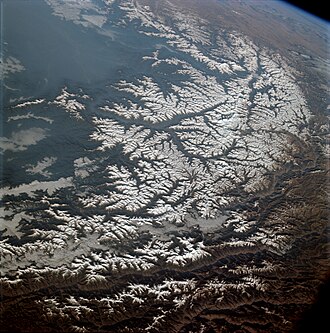
The Greater Caucasus is the big mountain range of the Caucasus Mountains. It runs for about 1,200 kilometres (750 mi) from west to east.
It starts from the Taman Peninsula by the Black Sea and goes all the way to the Absheron Peninsula by the Caspian Sea. This means it begins near the Western Caucasus close to Sochi and reaches almost to Baku.
The Greater Caucasus is an important part of the natural landscape in this area.
Geography
See also: Main Caucasian Range; Lateral Range; and Skalisty Range, Caucasus
The Greater Caucasus is a large mountain range with three main parts. The Western Caucasus lies between the Black Sea and Mount Elbrus. The Central Caucasus is between Mount Elbrus and Mount Kazbek. The Eastern Caucasus is between Mount Kazbek and the Caspian Sea.
In the Western Caucasus, where it is wetter, the mountains have many forests. There are leafy trees up to about 1,500 metres, cone-shaped trees up to about 2,500 metres, and grassy areas higher up. In the Eastern Caucasus, where it is drier, there are mostly no trees.
Europe–Asia boundary
The watershed of the Caucasus is sometimes seen as the boundary between Eastern Europe and Western Asia. The area north of this line is called Ciscaucasia, and the area south is Transcaucasia. This area is shaped by the Lesser Caucasus mountains blending into Eastern Anatolia.
Much of the border between Russia, Georgia, and Azerbaijan follows the length of the Caucasus. Important roads like the Georgian Military Road through the Darial Gorge and the Trans-Caucasus Highway cross these mountains.
Watershed
The watershed of the Caucasus used to mark the border between the Russian Empire to the north and the Ottoman Empire and Persia to the south. After a Russian victory and a treaty, the border moved further south. Today, the border between Georgia and Russia mostly follows this watershed. Georgia goes a little north of it in a few places. Most of Azerbaijan is south of the watershed, but six districts in the northeast are north of it.
Peaks
- Mount Elbrus, at 5,642 metres (18,510 feet), is the highest mountain in Europe.
- Dykh-Tau is 5,205 metres (17,077 feet) tall.
- Shkhara is 5,201 metres (17,064 feet) high.
- Koshtan-Tau is 5,151 metres (16,900 feet) tall.
- Shota Rustaveli Peak is 4,859 metres (15,942 feet) high.
- Kazbek rises to 5,047 metres (16,558 feet).
- Tebulosmta is 4,493 metres (14,741 feet) above sea level.
- Diklosmta is 4,285 metres (14,058 feet) tall.
- Bazardüzü is 4,466 metres (14,652 feet) tall.
- Babadag is 3,629 metres (11,906 feet) high.
- Katyn-Tau stands at 4,979 metres (16,335 feet).
- Pik Pushkina is 5,033 metres (16,512 feet) tall.
- Janga is 5,051 metres (16,572 feet) tall.
- Tetnuldi is 4,858 metres (15,938 feet) high.
- Ushba reaches 4,710 metres (15,450 feet).
- Ailama is 4,525 metres (14,846 feet) above sea level.
- Mount Karakaya, at 3,646 metres (11,962 feet), is the highest in the Skalisty Range of the Caucasus.
Passes
The Greater Caucasus has many high passes that connect different parts of the mountains. Some of these passes include Bogovatchosgele Pass, Abano Pass, and Mamison Pass. Others like Datvisjvari Pass, Marukhi Pass, and Pereval Klukhorskiy also offer challenging routes. The Jvari Pass and Dübrar Pass are additional notable pathways across these tall mountains.
Images
Related articles


This article is a child-friendly adaptation of the Wikipedia article on Greater Caucasus, available under CC BY-SA 4.0.
Images from Wikimedia Commons. Tap any image to view credits and license.