 Safekipedia
Ouachita Mountains
Adapted from Wikipedia · Adventurer experience
The Ouachita Mountains, often called the Ouachitas, are a mountain range in western Arkansas and southeastern Oklahoma. These mountains have very old rock layers that have bent and folded over time. They are part of an important mountain area in North America.
Deep below, the Ouachitas connect to the Appalachians to the northeast and to the Marathon uplift in West Texas to the southwest.
Together with the Ozark Plateaus, the Ouachitas form a special area called the U.S. Interior Highlands. This area is known for its unique plants, animals, and beauty. The highest point in the Ouachita Mountains is Mount Magazine, which stands at 2,753 feet (839 meters) above sea level. Scientists and the Environmental Protection Agency study this area to learn more about its plants and animals.
Etymology
The name "Ouachita" might come from the Choctaw words for "bison" and "large," meaning "country of large bison." Bison once lived in the lowland areas of the Ouachita Mountains. Another idea is that it comes from the Choctaw words for "hunt" and "big," meaning "big hunt far from home." It could also come from the Caddo word for "good hunting grounds."
Geography
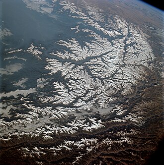
The Ouachita Mountains are a big group of hills and mountains in western Arkansas and southeastern Oklahoma. Together with the Ozark Plateaus, they are part of the U.S. Interior Highlands, one of the few mountainous areas between the Appalachians and the Rockies.
The Ouachitas have many types of trees, like pine, oak, and hickory. Some special plants grow only here. The Ouachita National Forest covers a large part of the Ouachitas and was set aside for protection long ago. Animals like white-tailed deer, coyotes, and black bears live in this area.
The Ouachitas include several smaller groups of mountains and hills, each with its own shape and features. Some of the taller points are over 2,500 feet above sea level. These areas are important for many plants and animals that live in the Ouachitas.
Geology
The Ouachita Mountains are made from old rock layers that have been bent and twisted. These rocks stretch for about 220 miles across western Arkansas and southeastern Oklahoma. The oldest rocks are in the middle of this area.
Unlike many other mountain ranges in the United States, the Ouachitas run mostly from east to west. They are special because they don’t have the usual features of mountain formation, such as volcanic activity. Instead, the Ouachitas have many folds and faults, creating smaller ranges with wide valleys between them.
The Ouachitas are famous for beautiful quartz crystals, especially near Mount Ida, Arkansas. These crystals formed long after the mountains were made, filling cracks in the rocks. The area is also known for a special type of rock called novaculite, used to make sharpening stones.
| Formation | Period | Approximate thickness |
|---|---|---|
| Collier Shale | Late Cambrian and Early Ordovician | 1,000 feet (300 m) |
| Crystal Mountain Sandstone | Early Ordovician | 850 feet (260 m) |
| Mazarn Shale | Early Ordovician | 2,500 feet (760 m) |
| Blakely Sandstone | Middle Ordovician | 700 feet (210 m) |
| Womble Shale | Middle Ordovician | 1,200 feet (370 m) |
| Bigfork Chert | Middle and Late Ordovician | 750 feet (230 m) |
| Polk Creek Shale | Late Ordovician | 225 feet (69 m) |
| Blaylock Sandstone | Silurian | 1,200 feet (370 m) |
| Missouri Mountain Shale | Silurian | 300 feet (91 m) |
| Arkansas Novaculite | Devonian and Early Mississippian | 900 feet (270 m) |
| Stanley Shale | Mississippian | 10,000 feet (3,000 m) |
| Jackfork Sandstone | Early Pennsylvanian | 6,000 feet (1,800 m) |
| Johns Valley Shale | Early Pennsylvanian | 1,500 feet (460 m) |
| Atoka Formation | Early and Middle Pennsylvanian | 25,000 feet (7,600 m) |
| Hartshorne Sandstone | Middle Pennsylvanian | 300 feet (91 m) |
| McAlester Formation | Middle Pennsylvanian | 2,300 feet (700 m) |
| Savanna Formation | Middle Pennsylvanian | 1,600 feet (490 m) |
| Boggy Formation | Middle Pennsylvanian | 1,100 feet (340 m) |
History
The Ouachita Mountains were home to the Ouachita tribe, and they were named after them. French explorers later changed the spelling. In 1541, Hernando de Soto was the first to explore the area. After the Louisiana Purchase in 1804, President Jefferson sent William Dunbar and Dr. George Hunter to study the region. In 1832, Hot Springs National Park became one of the first national parks in the United States. The Battle of Devil's Backbone happened there in 1863. In 1990, the U.S. Forest Service stopped using a certain logging method in the Ouachita National Forest.
Tourism
The Ouachita Mountains have many beautiful places to visit, such as the Ouachita National Forest, Hot Springs National Park, and Lake Ouachita. There are also many state parks and scenic drives, especially in Arkansas. One special place is the Ouachita National Recreation Trail, a long hiking trail that stretches for 223 miles from Talimena State Park in Oklahoma to Pinnacle Mountain State Park near Little Rock. This trail is great for hikers, backpackers, and mountain bikers in some parts.
The Talimena Scenic Drive starts in Mena and goes through beautiful, winding roads for 54 miles. It passes through the Winding Stair and Rich Mountains, with Rich Mountain reaching up to 2,681 feet tall. This drive is similar to the Blue Ridge Parkway in the Appalachian Mountains.
- Beavers Bend State Park
- Black Fork Mountain Wilderness
- Caney Creek Wilderness
- Cossatot River State Park-Natural Area
- Flatside Wilderness
- Heavener Runestone Park
- Hot Springs National Park
- Jack Creek Recreation Area
- Lake Catherine
- Lake Hamilton
- Lake Maumelle
- Lake Ouachita
- Mount Magazine State Park
- Pinnacle Mountain State Park
- Queen Wilhelmina State Park
- Mount Nebo State Park
Images
Related articles


This article is a child-friendly adaptation of the Wikipedia article on Ouachita Mountains, available under CC BY-SA 4.0.
Images from Wikimedia Commons. Tap any image to view credits and license.