 Safekipedia
Rhine
Adapted from Wikipedia · Adventurer experience
The Rhine is one of the big rivers of Europe. It starts in the Swiss canton of Graubünden in the southeastern Swiss Alps. The river flows through several countries, forming borders between Switzerland, Liechtenstein, Austria, Germany, and France before moving north through Germany and finally into the Netherlands, where it ends in the North Sea. It covers an area of 185,000 km2.
The Rhine's name comes from an old word from the Gaulish language, Rēnos. Many places are named after the river. This includes two German states: North Rhine-Westphalia and Rhineland-Palatinate, as well as French areas like Bas-Rhin and Haut-Rhin.
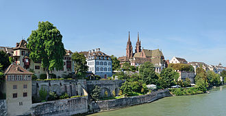
The Rhine is the second-longest river in Central and Western Europe, about 1,230 km (760 mi) long. It is very important for trade and travel, used since Roman times. Important cities along the river include Cologne, Rotterdam, Düsseldorf, Strasbourg, and Basel. The river also has Europe’s most powerful waterfall, the Rhine Falls.
Name
The Rhine has many names, depending on the language. In Latin, it was called Rhenus. In French, it is Rhin. The name comes from an old word, Rēnos, meaning "to move, flow, run". Over time, different cultures gave the river their own names. In German, it is Rhein, and in Dutch, it is Rijn. The name has changed over many years, showing how people have lived near and used the river.
Geography
The Rhine River is measured using a special scale called "Rhine-kilometers." This scale starts at the Old Rhine Bridge in the city of Konstanz and ends at the Hook of Holland. It covers a distance of 1,036.20 kilometers.
Over time, people have changed the river’s path by building canals. This has made the river shorter than its natural course. If you include Lake Constance and the Alpine Rhine, the total length is about 1,232 kilometers, or 766 miles.
Headwaters and sources
The Rhine begins in the Swiss Alps.
| Length | Section | Avg. discharge | Elevation | Left tributaries | Right tributaries |
|---|---|---|---|---|---|
| 76 km | The various sources and headwaters forming the Anterior and Posterior Rhine within Grisons, Switzerland | 116 m3/s | 584 m | Aua Russein, Schmuèr | Rein da Tuma, Rein da Curnera, Rein da Medel, Rein da Sumvitg (Rein da Vigliuts), Glogn (Valser Rhine), Rabiusa, Rein Posteriur/Hinterrhein (tributaries of which include the Ragn da Ferrera, Albula/Alvra, Gelgia, and Landwasser) |
| c. 90 km | The Alpine Rhine running through the Grisonian and St. Gall Rhine Valley (partly forming the Swiss border with Liechtenstein and Austria) | 245 m3/s | 400 m | Tamina, Saar | Plessur, Landquart, Liechtenstein inland canal, Ill, Frutz |
| c. 60 km | Lake Constance, including the short channel called Seerhein at Konstanz, connecting Obersee and Untersee | 364 m3/s | 395 m | Alter Rhein (Rheintaler Binnenkanal), Goldach, Aach | Dornbirner Ach, Bregenzer Ach, Leiblach, Argen, Schussen, Rotach, Brunnisach, Lipbach, Seefelder Aach, Stockacher Aach, Radolfzeller Aach |
| c. 150 km | The High Rhine from the exit of Lake Constance to Basel, forming a substantial part of the German-Swiss border | 1,089 m3/s | 246 m | Thur, Töss, Glatt, Aare, Sissle. Möhlinbach, Ergolz, Birs | Biber, Durach, Wutach, Alb, Murg, Wehra |
| 362 km | The Upper Rhine from Basel to Bingen forming the Upper Rhine Plain and in its upper course the Franco-German border | 79 m | Birsig, Ill, Moder, Lauter, Nahe | Wiese, Kander, Elz, Kinzig, Rench, Acher, Murg, Alb, Pfinz, Neckar, Main | |
| 159 km | The Middle Rhine between Bingen and either Bonn or Cologne is entirely within Germany, passing the Rhine Gorge; | 45 m | Moselle, Nette, Ahr | Lahn, Wied, Sieg | |
| 177 km | The Lower Rhine or Niederrhein downstream of Bonn, passing the Lower Rhine region of North Rhine-Westphalia | 11 m | Erft | Wupper, Düssel, Ruhr, Emscher, Lippe | |
| c. 50 km | The Nether Rhine or Nederrijn (shortened course of Oude Rijn within the Rhine–Meuse–Scheldt delta in the Netherlands) | 2,900 m3/s | 0 m | Meuse | Oude IJssel, Berkel |
Images
Related articles


This article is a child-friendly adaptation of the Wikipedia article on Rhine, available under CC BY-SA 4.0.
Images from Wikimedia Commons. Tap any image to view credits and license.