 Safekipedia
Sylhet Division
Adapted from Wikipedia · Adventurer experience
Sylhet Division
Sylhet Division is the northeastern part of Bangladesh. It covers an area of about 12,298 square kilometers and shares borders with India to the north, east, and south. The main city, also called Sylhet, is the fifth-largest urban area in Bangladesh.
Before 1947, Sylhet included a region now in India called Karimganj. However, after the Partition of India, Karimganj was separated from Sylhet.
Etymology
The Sylhet Division is named after its main city, Sylhet. The name "Sylhet" comes from an older local name, Śilhôṭ. This name is thought to have come from Śrīhaṭṭa, an ancient Sanskrit name for the city. The city of Śrīhaṭṭa was important to a group called the Nātha dynasty, who helped people live in the area between the twelfth and thirteenth centuries. Later leaders still used this old name.
History
Main articles: History of Sylhet and Undivided Sylhet district
In 1874, the area now called Sylhet Division was known as the 'Sylhet district'. That year, it was separated from Bengal and joined Assam to help trade grow. People in Sylhet were not happy at first, but they were told schools and courts would still be managed from Bengal, and they could find jobs and sell goods in Assam. In 1905, Sylhet joined Bengal again, but in 1912 it went back to Assam.
When India was divided in 1947, a vote decided if Sylhet would join India or Pakistan. Some leaders wanted Sylhet to stay with India, but the vote chose Pakistan, though some areas stayed with India. After Bangladesh became independent in 1971, Sylhet became part of Bangladesh. In 1984, the area was split into four districts, and in 1995, these districts formed Sylhet Division.
Sylhet has strong ties with the city of St Albans in the United Kingdom, starting in 1988 when St Albans helped with housing projects in Sylhet. Many people in the United Kingdom with roots in Bangladesh come from Sylhet, including communities in places like Rochdale, Oldham, and London.
Economy
Main article: Economy of Sylhet
Sylhet is famous for its tea. The Surma Valley has many tea gardens and tropical forests. Srimangal is called the tea capital of Bangladesh, with tea gardens covering the hills for miles around.
The area has many tea gardens, which provide jobs for many workers.
People from Sylhet living abroad have helped fund many projects and businesses. Sylhet also attracts visitors with its natural beauty, including places like the Keane Bridge, Ali Amjad's Clock, and Madhabkunda waterfall. It is also important for its spiritual sites, such as the resting place of Shah Jalal. There are many hotels and resorts, especially in Sreemangal and Bahubal.
Governance
Sylhet became the 6th division of the country in 1995 when it split from Chittagong Division. The Divisional Commissioner, Md. Mashiur Rahman, oversees it. Sylhet Division has four districts: Habiganj, Moulvibazar, Sunamganj, and Sylhet. These districts are split into 35 smaller areas called upazilas. Each upazila is divided into union parishads. There are about 10,185 villages in the Division. It also has 19 Municipal corporations, known as pourashavas, and one city corporation in Sylhet city. The main city of Sylhet Division is Sylhet, located in Sylhet Sadar Upazila, Sylhet District. Before 1947, the area known as Karimganj was part of India.
List of Upazilas in Sylhet Division
| Name | Capital | Area (km2) | Population 1991 Census | Population 2001 Census | Population 2011 Census | Population 2022 Census |
|---|---|---|---|---|---|---|
| Habiganj District | Habiganj | 2,536.58 | 1,526,609 | 1,757,665 | 2,089,001 | 2,358,747 |
| Moulvibazar District | Moulvibazar | 2,601.84 | 1,376,566 | 1,612,374 | 1,919,062 | 2,123,349 |
| Sunamganj District | Sunamganj | 3,669.58 | 1,708,563 | 2,013,738 | 2,467,968 | 2,695,294 |
| Sylhet District | Sylhet | 3,490.40 | 2,153,301 | 2,555,566 | 3,434,188 | 3,856,974 |
| Total District | 4 | 12,298.4 | 6,765,039 | 7,939,343 | 9,910,219 | 11,034,364 |
Geography
Sylhet Division is a beautiful area in the northeast of Bangladesh. It is surrounded by hills, except on the western side which is flat land. It has many parks and forests, like Lawachara National Park and Ratargul Swamp Forest.
The weather there is warm and wet, especially from April to October when there are heavy rains almost every day. The rest of the year is warm and clear.
The land in Sylhet has many hills and valleys. Some of the biggest valleys are called "beels." These are old oxbow lakes formed long ago. The area also has special animals like the Asian elephant and the One-horned rhinoceros, especially in the southern parts.
Culture
Main article: Culture of Sylhet
The official language in Sylhet is Standard Bengali. People use it in schools and government work. But most people speak the Sylheti dialect. Some groups, like the Adivasis and tea workers, speak their own languages too.
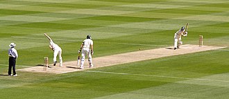
Cricket is the most popular sport in Sylhet. Football is also common, and there are special stadiums for these games. People also enjoy traditional games like Dosh Fochish, Ludo, Carrom Board, and Chess. During the rainy season, a rowing competition called Nowka Bais is popular. Other games include Kabaddi, Latim, and Lathi khela.
Demography
Sylhet Division has more than 12 million people, and most are Bengalis. Some groups, like the Bishnupriya Manipuris, Khasi, Lalengs, Tripuris, Meiteis, Garos, and Kukis, live mainly in quiet rural spots near hills and tea gardens. Long ago, the British brought people from other parts of British India to work on tea farms.
Religion
Most people in Sylhet follow Islam, especially Sunni Islam. Some also follow Sufi teachings. Hinduism is the second most common religion, practiced by many Bengalis and some tribal groups. Smaller groups follow Christianity, Ka Niam Khasi, Sanamahism, Songsarek, and animism.
In popular culture
In an episode of Call the Midwife, the midwives help a woman who comes from the Sylhet Division.
Images
Related articles


This article is a child-friendly adaptation of the Wikipedia article on Sylhet Division, available under CC BY-SA 4.0.
Images from Wikimedia Commons. Tap any image to view credits and license.