 Safekipedia
Dakota Territory
Adapted from Wikipedia · Explorer experience
The Dakota Territory
The Dakota Territory was a big piece of land that belonged to the United States. It existed from March 2, 1861, until November 2, 1889. Many families lived there and built their homes.
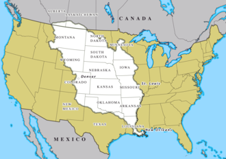
This land was named after the Dakota people, a group of the Sioux tribes, who lived in the area long ago. The Dakota Territory was made from land that came from the Louisiana Purchase and part of Rupert's Land.
Later, the Dakota Territory was split into two new states. On November 2, 1889, it became North Dakota and South Dakota. Now, these are two separate states with their own leaders and rules, just like other states in the country.
The story of the Dakota Territory helps us see how the United States grew bigger over time. People came from many places to live there, and they helped build towns, farms, and railroads.
Images
Related articles


This article is a child-friendly adaptation of the Wikipedia article on Dakota Territory, available under CC BY-SA 4.0.
Images from Wikimedia Commons. Tap any image to view credits and license.