 Safekipedia
South Island
Adapted from Wikipedia · Adventurer experience
The South Island, also known as Te Waipounamu, is the larger of the two main islands of New Zealand. It covers 150,437 square kilometres (58,084 sq mi), which makes it very big.
As of June 2025, it is home to 1,256,700 people. This is 24% of New Zealand's total population of 5.3 million.
The island is bordered by Cook Strait to the north, the Tasman Sea to the west, Foveaux Strait and the Southern Ocean to the south, and the Pacific Ocean to the east. The Southern Alps run along the island from north to south. The highest peak is Aoraki / Mount Cook, standing at 3,724 metres (12,218 feet).
Before Europeans arrived, the South Island was home to three major groups of people called iwi, including Kāi Tahu, Kāti Māmoe, and Waitaha. British settlers arrived and bought large areas of land. This led to growth in cities like Christchurch, Dunedin, Nelson, and Invercargill. During the 1860s, many people came to the South Island looking for gold.
Naming and usage
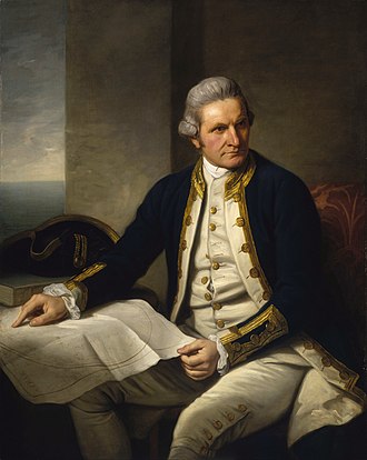
The South Island has been called the 'South Island' in English for many years. Its Māori name, 'Te Waipounamu', is also an official name. Captain James Cook wrote about it in 1769 when he visited New Zealand.
In the past, some maps called it 'Middle Island' or 'New Munster'. But in 1907, officials decided to always use 'South Island'. In 2013, both 'South Island' and 'Te Waipounamu' became the official names after public discussion.
People sometimes call the island 'the Mainland'. A train service named 'The Mainlander' will start in January 2026, connecting Christchurch, Dunedin, and Invercargill. There is also a cheese brand called Mainland that used to be made in Dunedin.
Māori mythology
The South Island is called Te Waka a Māui, meaning "Māui's Canoe." In some Māori stories, the South Island was Māui's boat.
Some Māori groups call the South Island Te Waka o Aoraki. This comes from a story about Aoraki and his three brothers. They traveled to visit their mother, Papatūānuku, the earth mother. On their way back to their father, Ranginui, they forgot a special prayer and crashed. The canoe turned into an island, and the brothers became mountains.
History
Further information: History of New Zealand and Timeline of New Zealand history
Early history (c. 1280 – c. 1820)
Further information: Māori history
Archaeological investigations of the Wairau Bar in the north east of the South Island show that this site was part of the first era of colonisation of New Zealand, around 1288–1300 CE. Wairau Bar is a rare example in New Zealand of an early East Polynesian settlement.
Rock art painted in red ochre and charcoal can be found on limestone rock shelters across the South Island. Stretching from Kaikōura to North Otago, the drawings are estimated to be between 500 and 800 years old and show animals, people and fantastic creatures. Some of the birds pictured are long extinct, including moa and Haast's eagles. They were drawn by early Māori.
Waitaha was an early Māori iwi (tribe) that settled in the South Island from the late 15th century. They were largely absorbed via marriage and conquest by the Kāti Māmoe in the 16th century. In the early 18th century, Ngāi Tahu, a Māori tribe who originated on the east coast of the North Island, began migrating to the northern part of the South Island. There they and Kāti Māmoe fought Ngāi Tara and Rangitāne in the Wairau Valley. Ngāti Māmoe then ceded the east coast regions north of the Waiau Toa / Clarence River to Ngāi Tahu. Ngāi Tahu continued to push south, conquering Kaikōura. By the 1730s, Ngāi Tahu had settled in Canterbury, including Banks Peninsula. From there they spread further south to Foveaux Strait and across into the West Coast. Kāti Māmoe were largely absorbed via marriage and conquest by the Ngāi Tahu as they migrated south.
European contact
The first known contact between Māori in the South Island and Europeans was when the Dutch explorer Abel Tasman arrived with his ships Heemskerck and Zeehaen. In December 1642, Tasman anchored in a bay at the northern end of the South Island that he named Murderers Bay following a clash with Māori. He then sailed north to Tonga.
British naval captain James Cook of HM Bark Endeavour visited the South Island on his first voyage to the southern Pacific Ocean, around 127 years after Tasman in 1769–70. In mid-January 1770, Cook arrived at Ship Cove in Queen Charlotte Sound, on the north coast of the South Island. Ship Cove became an early site for contact between Māori and Europeans, and Cook returned there during his second and third voyages. After leaving Ship Cove, Cook sailed down the east coast of the South Island, charting the coast and continuing the search for the southern continent. The Endeavour rounded South Cape, the southern-most point of Stewart Island on 10 March 1770, proving that the South Island was not the sought-after sixth continent.
From the 1780s, South Island Māori encountered European and American sealers and whalers. Some Māori crewed on the foreign ships, with many crewing on whaling and sealing ships that operated in New Zealand waters. Some of the South Island crews were almost totally Māori. Between 1800 and 1820, there were 65 sealing voyages and 106 whaling voyages to New Zealand, mainly from Britain and Australia.
In January 1827, the French explorer Jules Dumont d'Urville arrived in Tasman Bay on the corvette Astrolabe. A number of landmarks around Tasman Bay were named by d'Urville and his crew, including d'Urville Island, French Pass and Torrent Bay.
Musket wars 1827 – 1839
Main article: Musket Wars
In 1827–28, Ngāti Toa under the leadership of Te Rauparaha attacked and defeated Ngāi Tahu at Kaikōura. Ngāti Toa then visited Kaiapoi Pā (a fortified village), ostensibly to trade. When they attacked their hosts, the well-prepared Ngāi Tahu killed all the leading Ngāti Toa chiefs except Te Rauparaha, who returned to his Kapiti Island stronghold. In November 1830, Te Rauparaha persuaded Captain John Stewart of the brig Elizabeth to carry him and his warriors in secret to Akaroa, whereby in subterfuge they captured the leading Ngāi Tahu chief, Tama-i-hara-nui, and his wife and daughter. After destroying Tama-i-hara-nui's village, they took their captives to Kapiti. John Stewart was arrested and sent to trial in Sydney as an accomplice to murder, but escaped conviction.
In the summer of 1831–32 Te Rauparaha attacked the Kaiapoi Pā commencing a three-month siege. In 1832–33 Ngāi Tahu retaliated under the leadership of Tūhawaiki and others, attacking Ngāti Toa at Lake Grassmere. Fighting continued for a year or so, with Ngāi Tahu maintaining the upper hand.
In 1836, the Ngāti Tama chief Te Pūoho led a war party, armed with muskets, down the West Coast and over the Haast Pass. They fell on the Ngāi Tahu encampment between Lake Wānaka and Lake Hāwea. Te Puoho took his captives over the Crown Range to Lake Wakatipu and thence to Southland, where he was killed.
Ngāi Tahu and Ngāti Toa established peace by 1839, with Te Rauparaha releasing the Ngāi Tahu captives he held. Formal marriages between the leading families in the two tribes sealed the peace.
European settlement
The first permanent European settlement in the South Island was founded at Bluff in 1823 by whaler James Spencer who set up a trading post to supply visiting ships.
Akaroa, founded in 1840, is the oldest town in Canterbury. France wished to colonise New Zealand and sent out a group of immigrants who arrived at Akaroa on 18 August 1840 and established a French community there, supported by French naval officers and sailors.: 170–171 Following the signing of the Treaty of Waitangi at Waitangi in February 1840, Lieutenant-Governor Captain William Hobson declared British sovereignty over New Zealand on 21 May 1840 and the South Island, along with the rest of New Zealand, briefly became a part of the Colony of New South Wales. The Treaty was signed at Akaroa on 28 May 1840.
On 17 June 1843, Māori and British settlers clashed at Wairau in what became known as the Wairau Affray or Wairau Massacre. It was the first serious clash of arms between the two parties after the signing of the Treaty of Waitangi and the only one to take place in the South Island.
Settlement of Nelson began with the arrival of three New Zealand Company ships in November 1841. In March 1848, two ships carrying immigrants sponsored by the Free Church of Scotland arrived to begin settlement of Otago, and the Canterbury Settlement was established with the arrival of the 'First Four Ships' in Lyttelton in December 1850. Many more immigrant ships arrived in the South Island from the 1850s to the 1870s, and the population was also boosted by an influx of gold prospectors and miners in the 1860s. The European population of the South Island rose from 9,336 in 1851 to 296,644 (including Chinese) in 1881. For comparison, the non-Māori population of the North Island increased from 17,371 to 193,047 during the same period.
1860s gold rushes
Main articles: Otago gold rush and West Coast gold rush
Gold was discovered at Gabriel's Gully in Central Otago in May 1861, sparking a gold rush. Dunedin prospered, becoming New Zealand's largest and wealthiest city by the end of the 1860s. The West Coast gold rush lasted from 1864 to 1867, attracting miners from Otago and Australia. It is estimated that in 1867 around 29,000 people (12% of New Zealand's European population, mostly men) lived on the West Coast.
Several thousand Chinese men, mostly from Guangdong, moved to New Zealand to work on the South Island goldfields, firstly in Otago and Southland and then on the West Coast. In 1882, about 40% of the population at the alluvial gold workings at Inangahua was Chinese. Although the first Chinese workers had been invited by the Otago Provincial government, they quickly became the target of hostility from white settlers.
Public works and infrastructure
With the onset of the West Coast gold rush in 1864, the Canterbury Provincial Government wanted to find a way over the Southern Alps from Canterbury to the West Coast. Investigation showed that a route via what is now known as Arthur's Pass was the best option, and in 1866 a road over the pass to Hokitika was opened.
The Lyttelton Rail Tunnel through the Port Hills opened in 1867, providing efficient movement of goods between the port at Lyttelton and Christchurch. The Main South Line railway linking Christchurch, Dunedin, and Invercargill was opened in 1878. The Midland rail line between Christchurch and Greymouth opened in 1923. The Otira Tunnel on the Midland Line runs under the Southern Alps between Arthur's Pass and Otira, a length of over 8.5 kilometres (5.3 mi). When the Otira Tunnel opened on 4 August 1923, it was the seventh longest tunnel in the world and the longest in the British Empire.
Hydroelectricity
Main article: Hydroelectric power in New Zealand
Most of New Zealand's hydroelectric power is generated in the South Island and used in the North Island.
In August 1888, Reefton became the first locality in New Zealand to light its streets with electricity, using water from the Inangahua River to power a dynamo. (The first city to use electric street lighting was Wellington, in June 1889).
Early schemes such as the Waipori scheme in Otago, commissioned in 1903, and the Lake Coleridge power station commissioned in 1914 established New Zealand's use of hydroelectric energy. Roxburgh Dam began operating in 1956. By the early 1960s, most North Island hydro sites had been developed but the South Island still had many potential sites. Commissioning of the HVDC Inter-Island link in 1965 made it possible to send large amounts of electricity between the two islands, and from that time hydro capacity in the South Island increased rapidly. Major South Island developments included the Benmore Power Station (1966), Manapouri power station (1971), the Upper Waitaki River Scheme (1977–85) and the Clyde Dam (1992).
Construction of hydroelectric schemes in the South Island has met some opposition. The first nationwide environmental campaign in New Zealand was opposition to raising the water level of Lake Manapouri for a power station to supply electricity to the Tiwai Point Aluminium Smelter. The Save Manapouri Campaign was a success and the power station was built without raising the level of the lake outside of its natural range.
Construction of the Clyde Dam near Cromwell created Lake Dunstan, which meant that many of Cromwell's buildings had to be relocated from the area to be flooded.
High country farming
From the 1850s, settlers established high country stations on dry tussock-covered land 600m or more above sea level in central Otago and in the foothills of the Southern Alps in Canterbury. High country stations typically farmed sheep, often using sheep farming methods from the Scottish Highlands. Wool was a valuable product that did not spoil when transported long distances. Life on high country stations revolved around an annual cycle of mustering (bringing the animals down from the hills), shearing, lambing, weaning and winter feeding, and a mythos grew up around the image of the stoic 'Southern man' working alone on the hills. Runholders built huts and sheds for the annual cycle of mustering and shearing sheep. The Department of Conservation now manages a number of historic huts and sites related to high country farming in Nelson/Marlborough, Canterbury, Otago and Southland. A few sites are administered by Heritage New Zealand.
The government owned the land and leased it to runholders on 99-year leases. Between 1880 and the early 1900s, many properties were abandoned or destocked for various periods because of problems caused by overgrazing, animal disease issues, weather events and plagues of rabbits. Rabbits had been introduced to New Zealand in the 1830s but quickly became a problem. They depleted pasture, which encouraged weeds to take over, and accelerated erosion in hill country.
By 1948 much of the South Island high country was in a poor state, so the Crown introduced the Land Act 1948. This provided for "a perpetually renewable ’pastoral lease’ to give farming families on these lands the ability to farm for future generations and long-term sustainability". The farmer has exclusive possession of the land and the right to graze it, and owns improvements made such as fencing and buildings. The farmer does not own the soil and must keep pests and weeds under control.
High country sheep farming became less profitable from about this time due to higher labour costs, loss of subsidies, environmental issues and lower returns. The Crown Pastoral Land Act 1998 began a process of tenure review. Runholders could gain freehold title to areas that could be "sustainably farmed", while unsustainable land would revert to management by DOC for conservation purposes. The Act was controversial.
Geography
Main article: Geography of the South Island
The South Island is the biggest part of New Zealand. It is 150,437 km2 and has about one-quarter of the country's people. The island is split by the Southern Alps. The highest peak is Aoraki / Mount Cook, which is 3,724 metres tall. The east side has flat lands, while the west has rough coasts and glaciers.
The South Island sits between two moving pieces of Earth's surface. This movement causes earthquakes and makes mountains rise. The Southern Alps were formed this way and are still growing. The island also has many glaciers, lakes, and deep valleys, especially in the southwest. These were shaped by old glaciers that carved the land and left lakes when they melted.
Demographics
Further information: List of cities and towns in the South Island and Cities and towns of the South Island by population
Population
The South Island has fewer people than the North Island. As of June 2025, about 1,256,700 people live there.
In the past, more people lived on the South Island. Events like the New Zealand Wars and the Otago goldrush changed this. Recently, the South Island’s share of New Zealand’s total population has stayed about the same, around 23%–24%. In 2023, the South Island had 1,185,282 people, which is a bit more than in 2018.
Many people moved from the North Island to the South Island between 2018 and 2023.
Most people on the South Island identify as New Zealand European. Many also identify as Māori, Chinese, Indian, or Filipino. Some people were born in other countries, like England, the Philippines, or Australia.
Urbanisation
The South Island has lots of open spaces and nature. But there are 16 places with 10,000 or more people.
| Year | Pop. | ±% p.a. |
|---|---|---|
| 1991 | 852,843 | — |
| 1996 | 899,382 | +1.07% |
| 2001 | 906,759 | +0.16% |
| 2006 | 1,022,313 | +2.43% |
| 2013 | 1,058,058 | +0.49% |
| 2018 | 1,149,564 | +1.67% |
| 2023 | 1,185,282 | +0.61% |
| Source: | ||
| Name | Population (June 2025) | % of island |
|---|---|---|
| Christchurch | 407,800 | 32.5% |
| Dunedin | 104,000 | 8.3% |
| Invercargill | 51,200 | 4.1% |
| Nelson | 50,800 | 4.0% |
| Rolleston | 34,100 | 2.7% |
| Blenheim | 29,800 | 2.4% |
| Timaru | 29,300 | 2.3% |
| Queenstown | 29,000 | 2.3% |
| Ashburton | 21,600 | 1.7% |
| Richmond | 19,950 | 1.6% |
| Rangiora | 19,300 | 1.5% |
| Mosgiel | 15,100 | 1.2% |
| Oamaru | 14,300 | 1.1% |
| Kaiapoi | 13,700 | 1.1% |
| Wānaka | 13,200 | 1.1% |
| Lincoln | 12,100 | 1.0% |
Culture
In art
The South Island’s beautiful landscapes have inspired many famous New Zealand artists. In the 1800s, John Gully painted scenes from the island using watercolors. Rita Angus, who lived in Christchurch, painted many pictures of the Canterbury and Otago areas. Her painting Cass, showing a quiet railway station, was chosen as New Zealand’s favorite painting in a TV show. Other artists like Toss Woollaston, Leo Bensemann, and Grahame Sydney also created works showing the South Island’s landscapes.
The South Island has been a popular place for movies, including parts of the The Lord of the Rings trilogy and _The Chronicles of Narnia: The Lion, the Witch and the Wardrobe.
Language
In the southern part of the South Island, near Southland and Otago, people speak with a special accent called the "Southland burr." This accent has influences from Scottish English.
The South Island also has its own version of the Māori language.
Religion
Main article: Religion in New Zealand
More than half of the people on the South Island say they do not follow any religion. Anglicanism is the most common Christian religion there, especially in Canterbury. Catholicism is also strong, particularly on the West Coast and in Kaikōura. Presbyterianism is popular in places like Dunedin, Gore, and Southland. The first Muslims in New Zealand were a few Chinese people who came to work in the gold fields of Otago in the 1860s.
Governance
Further information: New Zealand Constitution Act 1846, New Munster Province, and Provinces of New Zealand
The South Island has sixteen general electorates and one Māori electorate in the New Zealand House of Representatives. Local government works like the rest of the country. Regional councils handle bigger areas, and territorial authorities take care of local needs. In the upper part of the island, Nelson, Tasman, and Marlborough combine both regional and local duties as unitary authorities. There are four regional councils (West Coast, Canterbury, Otago, and Southland) and 23 territorial authorities.
Independence movements
Sometimes, people in the South Island have wanted to be separate from the rest of New Zealand. One leader, Sir Julius Vogel, suggested this idea in 1865, and it was discussed in the New Zealand Parliament. Moving the capital from Auckland to Wellington was partly because of this wish.
In the late 1990s and early 2000s, some groups wanted the South Island to make its own decisions. The South Island Party tried to join elections in 1999 but stopped in 2002. Today, some online groups still talk about letting the South Island decide more for itself.
Economy
Further information: List of South Island companies
The South Island's economy is mainly about tourism and farming. Other important areas include making things, mining, building, energy, schools, and health services.
The South Island makes up about 22% of New Zealand's total money from work and services. Each person in the South Island helps create around $65,875 worth of goods and services each year.
Energy
The South Island is a big place for making electricity, especially using water. In 2010, it made about 18.01 TWh of electricity, which is more than 40% of all the electricity in New Zealand. Almost all of this electricity comes from water, mostly from places like the Waitaki, Clutha, and Manapouri areas. Some electricity is also made from wind. Most of the electricity is used in the South Island, but some is sent to the North Island.
Tourism
Tourism is very important for the South Island. People love to visit for activities like seeing beautiful places, climbing glaciers, jumping from tall heights, hiking, kayaking, and camping. The South Island has many famous walking trails, including six of New Zealand's top walks.
More international flights to Christchurch, Dunedin, and Queenstown have brought more visitors from other countries.
Beautiful places like Fiordland National Park, Abel Tasman National Park, Westland Tai Poutini National Park, Aoraki / Mount Cook National Park, Queenstown, Kaikōura, and the Marlborough Sounds are some of the most popular spots. Most of New Zealand's ski areas are also in the South Island.
Transport
Main article: Transport in New Zealand
The South Island has many roads, totaling 4,921 kilometres. A major road, SH 1, runs down the east coast from Picton through cities like Christchurch and Dunedin to Stirling Point near Bluff. Another important road, SH 6, starts from Blenheim, goes through Nelson, crosses the Southern Alps, and ends in Invercargill.
The island also has railways with two main lines and some smaller ones. Trains used to travel all over, but now most passenger trains only run between certain cities. Ferries cross Cook Strait, which separates the South Island from the North Island, taking about three to three and a half hours to travel.
The biggest airport is Christchurch Airport, which handles many flights. Some international flights also use Dunedin Airport and Queenstown Airport.
Images
Related articles


This article is a child-friendly adaptation of the Wikipedia article on South Island, available under CC BY-SA 4.0.
Images from Wikimedia Commons. Tap any image to view credits and license.