 Safekipedia
Western Ghats
Adapted from Wikipedia · Discoverer experience
The Western Ghats, also known as the Sahyadri, is a mountain range that stretches 1,600 km (1,000 mi) along the west coast of India. It covers an area of 160,000 km² (62,000 mi²) and goes through several Indian states: Gujarat, Maharashtra, Goa, Karnataka, Kerala, and Tamil Nadu. These mountains form a long chain along the western edge of the Deccan Plateau, starting from the Tapti River and ending at Swamithoppe in Kanyakumari district.
The Western Ghats were formed when the supercontinent of Gondwana broke apart. This happened during the late Jurassic and early Cretaceous periods as India moved away from the African continent. The mountains have three main parts: a northern section, a middle section south of Goa, and a southern section. The highest peak is Anamudi, which rises to 2,695 m (8,842 ft).
These mountains are very important for India’s water supply and climate. They help create rain along the western coast by blocking moist monsoon winds from the Arabian Sea. This also creates a dry area on the other side called a rain shadow. The Western Ghats are home to many unique plants and animals, including many that are in danger of disappearing. In 2012, this area was named a UNESCO World Heritage Site.
Etymology
The name Western Ghats comes from the word ghat and the direction it faces compared to the rest of India. In many parts of India, the word "ghat" can mean either a row of steep hills, like the Western Ghats, or steps leading down to water. Experts think "ghat" comes from words in southern Indian languages, such as "kattu" in Tamil, meaning mountain side or ridge. The mountains are also called "Sahyadri", a name from Sanskrit that means kind or gentle mountain.
Geology
The Western Ghats are the tall, rugged edge of the Deccan Plateau. They were formed when the huge ancient landmass called Gondwana broke apart. This process created rocks called basalt that pushed up the land on the western side.
Studies using special science tools show that these mountains grew along India’s west coast long ago, when India moved away from Africa. Many cracks, or faults, in the earth helped shape the mountains, creating valleys and deep gorges where rivers flow. Because the land rises on the west, most rivers run from west to east, making the eastern slopes gentle and the western slopes steep.
Geography
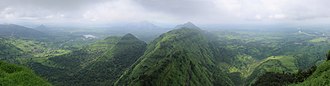
The Western Ghats stretch for about 1,600 km (990 mi) along the west coast of India, starting south of the Tapti River and ending at Marunthuvazh Malai in Swamithoppe, Kanyakumari district. They cover an area of 160,000 km2 (62,000 sq mi) and go through several Indian states, including Gujarat, Maharashtra, Goa, Karnataka, Kerala, and Tamil Nadu.
The Western Ghats are a chain of mountains that run parallel to India's western coast along the Arabian Sea. They have an average height of about 1,200 m (3,900 ft). There are three gaps in these mountains: the Goa Gap, the Palghat Gap, and the Shencottah Gap. The narrow area between the mountains and the sea is called the Western Coastal Plains.
The mountains can be split into three parts: the northern part, the middle part, and the southern part, each with different heights. The highest peak is Anamudi, which rises to 2,695 m (8,842 ft). The Western Ghats help create important rivers like the Godavari, Kaveri, and Krishna. Many of these rivers flow east towards the Bay of Bengal, and they sometimes form beautiful waterfalls. The rivers are also used for hydroelectric power and irrigation.
Climate
The Western Ghats help decide the weather and seasons in India. In the dry months of April and May, heat on the land pulls air from the sea. This air, carrying moisture from the Arabian Sea, is stopped by the Western Ghats. As the air rises, it cools and creates rain along the western coast, marking the start of the monsoon season in June. By the time the air passes over the mountains, it becomes dry, leaving a dry area called a rain shadow on the other side.
The climate in these mountains changes with height. Because it is close to the equator and the Arabian Sea, the area stays warm and humid all year. Temperatures are usually between 20 °C and 24 °C. In higher areas, it can get much colder, even near zero during winter. The southern part gets the most rain during the monsoon. Rainfall ranges from 100 cm to 900 cm yearly, averaging about 250 cm. Some places in northern Maharashtra get heavy rain but then go through long dry periods, while areas closer to the equator have less rain but it falls over many months.
orographic precipitation monsoon rain shadow leeward Bay of Bengal equator tropical climate
Biodiversity
The Western Ghats region is a biodiversity hotspot. It contains nearly 30% of all the plants and animals found in India, with most of these species living only in this area. At least 325 globally threatened species can be found in the Western Ghats.
Flora
The Western Ghats include four different types of moist forests, with the northern part usually drier than the southern part. These forests have many types of plants, including dry forests, scrub forests, peat bogs, and swamps. High mountain grasslands with special forests called sholas are also found here.
Scientists have recorded thousands of plant species in the Western Ghats. Many of these plants grow only in this region. There are also many types of mosses, liverworts, ferns, and lichens.
Fauna
The Western Ghats are home to many animal species, including at least 325 globally threatened species. There are over 6,000 types of insects here.
The region has a large population of tigers, with about 985 in 2022. It also has the largest wild population of Indian elephants, with around 11,000. Other animals include the lion-tailed macaque, Nilgiri tahr, leopards, Nilgiri langur, dhole, and gaur. There are also many types of birds, reptiles, and amphibians, including several that live only in this area.
The Western Ghats have many kinds of fish and molluscs too. Some fish species are found only here, and there are also many types of freshwater snails and mussels.
Threats and conservation
Historically, the Western Ghats were covered with thick forests that provided homes for many animals and native tribal people. During British colonial rule, large areas were cleared for farming and timber, which hurt many plant and animal species.
Today, the Government of India protects the Western Ghats with many protected areas, including two biosphere reserves, 13 national parks, and several wildlife sanctuaries. In 2012, parts of the Western Ghats were declared World Heritage Sites by UNESCO.
| Region | Area | Areas covered |
|---|---|---|
| North Western Ghats montane rain forests | 11,900 mi2 (31,000 km2) | Goa, Karnataka, Maharashtra, Tamil Nadu |
| South Western Ghats montane rain forests | 8,700 mi2 (23,000 km2) | Kerala, Tamil Nadu |
| North Western Ghats moist deciduous forests | 4,831 mi2 (12,510 km2) | Gujarat, Karnataka, Maharashtra |
| South Western Ghats moist deciduous forests | 2,382 mi2 (6,170 km2) | Karnataka, Kerala, Tamil Nadu |
| Taxonomic group | Species | Endemic | % Endemic | Endangered |
|---|---|---|---|---|
| Mammals | 120 | 14 | 12% | 31 |
| Birds | 508 | 19 | 4% | 15 |
| Amphibians | 121 | 94 | 78% | 43 |
| Reptiles | 156 | 97 | 62% | 5 |
| Fishes | 218 | 116 | 53% | 1 |
Images
Related articles


This article is a child-friendly adaptation of the Wikipedia article on Western Ghats, available under CC BY-SA 4.0.
Images from Wikimedia Commons. Tap any image to view credits and license.