 Safekipedia
Zambezi Region
Adapted from Wikipedia · Discoverer experience
The Zambezi Region, known as the Caprivi Region until 2013, is one of Namibia's fourteen regions. It is located in the north-eastern part of the country along the Zambezi River. The whole region sits in a narrow stretch of land called the Caprivi Strip.
The capital of the Zambezi Region is a town named Katima Mulilo. Near this town, there is an airport called the Katima Mulilo Airport, about 18 kilometres to the south-west. A smaller place named Bukalo is a bit further away, around 43 kilometres south-east of Katima Mulilo.
The region is divided into eight areas for voting, called electoral constituencies. In a count done in 2023, about 142,373 people lived there.
Politics
The Zambezi Region has eight areas called electoral constituencies. These include places like Judea Lyaboloma, Kabbe North, Kabbe South, Katima Mulilo Rural, Katima Mulilo Urban, Kongola, Linyanti, and Sibbinda.
In elections, a group called the South West Africa People's Organization (SWAPO) usually wins. In 2004, they won all the constituencies. In 2015, they also won all eight and got most of the votes. But in 2020, they still had many votes but lost some areas to other groups.
Geography
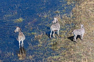
The Zambezi Region is a tropical area with warm weather and lots of rain from December to March, making it the wettest part of Namibia. The land here includes swamps, floodplains, wetlands, and woodlands.
Besides the Zambezi River, the region also has the Kwando River, which forms the border with Botswana. The region is home to many animals, including elephants, and has several national parks that help protect wildlife. It is also a great place for watching birds, with almost 70 percent of Namibia's bird species found here. The main town is Katima Mulilo, and there are many other smaller settlements in the area.
Economy and infrastructure
The Zambezi Region in Namibia has many schools and some jobs, but many people are looking for work. The region is also known for its beautiful natural areas that attract visitors.
The area has several large parks, such as Bwabwata National Park, Nkasa Rupara National Park, and Mudumu National Park. These parks have many animals and birds, and visitors can see elephants, buffaloes, and many types of antelope. During the rainy season, some parts of the parks flood and become hard to reach. There is also a special tourism route called The Namibian Wetland Route that takes visitors through interesting places in the region.
History
See also: Caprivi Strip
The area now known as the Zambezi Region was once called Itenge and was ruled by the Lozi kings. Later, it became part of the British area called Bechuanaland (now Botswana). In 1890, Germany and Britain made an agreement, and Germany took control of a narrow strip of land, naming it after a German leader, Leo von Caprivi. This strip, called the Caprivi Strip, was meant to connect Germany’s colony in Africa to the Zambezi River.
During World War I, the area was taken over by Britain again. In 1990, when Namibia became independent, the Caprivi Strip became one of the country’s regions. In 2013, the name was changed from Caprivi to Zambezi to remove the name of a former colonial leader and honor the river nearby. Some people were not happy with this change, feeling it would lessen their local identity and history.
Demographics
The Zambezi Region is home to 142,373 people. In this area, there are more women than men. Most people live in rural areas, with only about a third living in towns. The region has a population density of 9.7 people per square kilometer.
Many people in the Zambezi Region are not from Namibia, making up about 16.5% of the population. There are around 37,296 households, with an average of 3.7 people in each. The population is growing quickly, with a yearly increase of 3.8%. Families tend to have many children, with an average of 4.5 children per woman. About one in six people is under five years old.
Most adults in the region are married, either through traditional ceremonies, with certificates, or in other ways. However, some young people marry before they turn 18.
When it comes to education, many people have only completed primary school, while fewer continue to secondary or tertiary education. About one in three people earn their living through wages or salaries, while others rely on farming, pensions, or running businesses.
Over the years, access to basic services has improved. Today, most people have clean drinking water, and more have electricity in their homes. However, access to toilets and the internet remains limited, with only about a quarter having internet access and less than half owning a cellphone.
Related articles




This article is a child-friendly adaptation of the Wikipedia article on Zambezi Region, available under CC BY-SA 4.0.
Images from Wikimedia Commons. Tap any image to view credits and license.