 Safekipedia
Greater Los Angeles
Adapted from Wikipedia · Adventurer experience
Greater Los Angeles is the biggest city area in the U.S. state of California. It is made up of five counties in Southern California. It stretches from Ventura County in the west to San Bernardino County and Riverside County in the east. In the middle is the city of Los Angeles, and to the southeast is Orange County. This huge area covers 33,954 square miles (87,940 km2), making it the largest city area in the United States by size.
With more than 18.3 million people, Greater Los Angeles is the second-most crowded city area in the country, just after New York. It is very important for many reasons. It is home to the world's movie, television, and music industries. It is also a key place for trade, learning, news, business, travel, new technology, and sports. Its economy is worth over $1 trillion, putting it as the third-largest city area in the world for money made, after New York City and Tokyo.
There are three main parts close together in Greater Los Angeles. One is the Inland Empire, which includes Riverside County and San Bernardino County. Another is the Ventura/Oxnard area in Ventura County. The third is the Los Angeles metropolitan area, which includes Los Angeles County and Orange County. Even though San Diego–Tijuana is close by, it is not part of Greater Los Angeles because the two areas are not directly connected.
Definitions
Los Angeles metropolitan area
The Los Angeles metropolitan area is called the Los Angeles–Long Beach–Anaheim, CA Metropolitan Statistical Area (MSA). In 2021, about 12,997,353 people lived there. This area is split into two parts:
- Los Angeles–Long Beach–Glendale, CA Metropolitan Division, which is the same as Los Angeles County, California (2023 population 9,663,345)
- Anaheim–Santa Ana–Irvine, CA Metropolitan Division, which is the same as Orange County, California (2023 population 3,135,755)
This MSA is the biggest metropolitan area in the Western United States and the second biggest in the entire United States. It centers around the Los Angeles–Long Beach–Anaheim area.
Greater Los Angeles
The U.S. Census Bureau also talks about a larger area based on where people work and travel, called the Los Angeles–Long Beach, CA Combined Statistical Area (CSA), often known as the Greater Los Angeles Area. In 2023, about 18,316,743 people lived there. The total land area of the CSA is 33,955 square miles (87,945 km2).
The CSA includes three smaller areas:
- The Los Angeles–Long Beach–Anaheim, CA MSA (2023 pop. 12,799,100), which includes:
- Los Angeles County, California (2023 pop. 9,663,345)
- Orange County, California (2023 pop. 3,135,755)
- The Oxnard–Thousand Oaks–Ventura, CA MSA, which is the same as Ventura County (2023 pop. 829,590)
- The Riverside–San Bernardino–Ontario, CA MSA (2023 pop. 4,688,053), which includes:
- Riverside County, California (2023 pop. 2,492,442)
- San Bernardino County, California (2023 pop. 2,195,611)
| Area (km2) | Population (2024) | GDP (million US$, 2024) | GDP per capita (US$) | |
|---|---|---|---|---|
| Los Angeles–Long Beach–Anaheim, CA (MSA) | 12,580 | 12,906,895 | 1,354,718 | 104,961 |
| Riverside–San Bernardino–Ontario, CA (MSA) | 70,610 | 4,747,876 | 272,671 | 57,430 |
| Oxnard–Thousand Oaks–Ventura, CA (MSA) | 4,770 | 833,431 | 69,606 | 83,517 |
| Los Angeles–Long Beach, CA CSA | 87,960 | 18,488,202 | 1,696,995 | 91,788 |
History
Main article: History of Los Angeles
Most of the Greater Los Angeles area is where the Tongva people lived. They are also called the Tovaangar. They were the native people here long before cities were built.
Geography
See also: Southern California § Geology
Urban form
Los Angeles is famous for its spread-out layout. This happened because the city grew with homes and businesses far apart, a style that later became common in many cities. In 2000, the Los Angeles–Orange County area had the most people living close together in the United States.
Los Angeles grew quickly into one of America’s biggest cities. Cars and streetcars made it easier for people to live far from downtown. Important places for jobs, shopping, and fun appeared outside the main downtown area, like in Mid-Wilshire, Miracle Mile, and Hollywood. This pattern continued, especially after freeways were built in the 1950s. Now, important buildings and activities are spread out all over the area. Buildings in Los Angeles are usually not very tall because of rules about how close together things can be built.
Starting in the early 1900s, many people moved to areas like the San Fernando Valley and the Conejo Valley in Ventura County. This growth continued through the 1960s and 1970s. Building more freeways made it easier to travel to Los Angeles. In recent years, building new homes and updating old office buildings in downtown Los Angeles has become very active.
Major business districts and edge cities
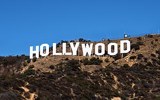
The traditional downtown area of Greater Los Angeles is Downtown Los Angeles. But most shops and offices are in places like Century City, Wilshire Boulevard in Koreatown, Hollywood, the Sunset Strip in West Hollywood, Universal City, Warner Center in Woodland Hills, Sherman Oaks, and Encino. These areas have lots of jobs and fun things to do, even though they are in suburban parts of the city.
Since the COVID-19 pandemic, Downtown Los Angeles has had many empty office buildings.
Other important downtown areas in the larger Los Angeles region include Downtown Long Beach, downtown Pasadena, downtown Glendale, downtown Burbank, Downtown Santa Ana, Downtown Anaheim, Downtown Riverside, Downtown San Bernardino, downtown Irvine, and downtown Ontario.
Identity
In Greater Los Angeles, people work and live in many different places. Many people travel from one part of the area to another for jobs and everyday life. People in Los Angeles don’t always think of themselves as part of one big region. For example, people living in Orange County and Los Angeles County often see themselves as very different, even though they are part of the same big area. Some people in Orange County don’t like to be grouped with Los Angeles. Also, many people from Riverside County and San Bernardino County travel to Los Angeles County or Orange County for work.
Component counties, subregions, and cities
Los Angeles County
Main article: Los Angeles County, California
Los Angeles County is the most populous county in the United States, home to many California residents. The city of Los Angeles, the county seat, has a big size and history of taking in smaller towns. Many cities are around Los Angeles and are often thought of as part of its areas even though they are separate. Examples include Santa Monica and Beverly Hills, almost completely around Los Angeles, and Hawthorne and Inglewood, linked to South Los Angeles. Areas outside the city of Los Angeles but next to it include the Santa Clarita Valley, the San Gabriel Valley, South Bay, and the Gateway Cities.
Much of Los Angeles County’s land is not part of any city and is managed by the county. Geographic features like the Santa Monica Mountains, the San Gabriel Mountains, and the Mojave Desert make building hard in many areas. Building happens mostly around the edges of cities, some of which, like Palmdale and Lancaster, have been fully built up.
Subregions in Los Angeles County
While there is no official name, the Los Angeles Times divides the area into several regions, including:
- Angeles Forest
- Antelope Valley
- Central L.A. (Downtown Los Angeles, Hollywood, Mid-Wilshire, etc.)
- Eastside
- Gateway Cities/Harbor Area
- Northeast L.A. (Highland Park, Eagle Rock, etc.)
- Northwest L.A. County (including the Santa Clarita Valley)
- Pomona Valley (partially in San Bernardino County)
- San Fernando Valley
- San Gabriel Valley
- Santa Clarita Valley
- Santa Monica Mountains (Malibu, Topanga, etc.)
- South Bay (incl. Palos Verdes Peninsula, Beach Cities)
- South Los Angeles
- Southeast Los Angeles County (including Norwalk and Whittier, see Gateway Cities)
- The Verdugos (including Glendale, Pasadena and the Crescenta Valley)
- Westside
Some areas are defined by natural features, while others are marked by city borders, roads, or other man-made signs. For example, Downtown Los Angeles is roughly enclosed by three roads and one river. The San Fernando Valley is defined as the area north-northwest of downtown, surrounded by mountains.
Edge cities in Los Angeles County
Central and Western area
- Beverly Hills/Century City
- LAX/El Segundo
- Marina Del Rey/Culver City
- West Los Angeles
- Mid-Wilshire
- Miracle Mile
San Fernando Valley
Elsewhere in Los Angeles County
- Pasadena
- South Bay/Torrance/Carson
- South Valley/Covina (emerging edge city as of 1991)
- Santa Clarita (emerging edge city as of 1991)
Cities in Los Angeles County
With a big population, the City of Los Angeles is the second most populous city in the United States after New York City. It is a global center for money, entertainment, media, culture, education, travel, and science.
List of the 88 cities of Los Angeles County and six large CDPs by population at the 2020 U.S. census:
- Los Angeles
- Long Beach
- Santa Clarita
- Glendale
- Lancaster
- Palmdale
- Pomona
- Torrance
- Pasadena
- East Los Angeles CDP
- Downey
- West Covina
- El Monte
- Inglewood
- Burbank
- Norwalk
- Compton
- Carson
- Santa Monica
- South Gate
- Hawthorne
- Whittier
- Alhambra
- Lakewood
- Bellflower
- Baldwin Park
- Redondo Beach
- Lynwood
- Montebello
- Pico Rivera
- Florence-Graham CDP
- Monterey Park
- Gardena
- Arcadia
- South Whittier CDP
- Diamond Bar
- Huntington Park
- Hacienda Heights CDP
- Paramount
- Glendora
- Covina
- Rosemead
- Azusa
- Cerritos
- Rowland Heights CDP
- La Mirada
- Altadena CDP
- Rancho Palos Verdes
- Culver City
- San Gabriel
- Bell Gardens
- La Puente
- Monrovia
- Claremont
- Temple City
- West Hollywood
- Manhattan Beach
- San Dimas
- Bell
- Beverly Hills
- Lawndale
- La Verne
- Walnut
- South Pasadena
- Maywood
- San Fernando
- Calabasas
- Cudahy
- Duarte
- Lomita
- La Cañada Flintridge
- Agoura Hills
- Hermosa Beach
- South El Monte
- Santa Fe Springs
- El Segundo
- Artesia
- Hawaiian Gardens
- Palos Verdes Estates
- San Marino
- Commerce
- Signal Hill
- Sierra Madre
- Malibu
- Rolling Hills Estates
- Westlake Village
- La Habra Heights
- Avalon
- Rolling Hills
- Hidden Hills
- Irwindale
- Bradbury
- Industry
- Vernon
Orange County
Main article: Orange County, California
Orange County was originally an area with farms, growing oranges, avocados, and oil. It became a bedroom community for Los Angeles when I–5, the Santa Ana Freeway linked it to the city in the 1950s. The growth of Los Angeles first drove population growth in Orange County, but by the 1970s it had become an important economic center of its own, with tourism and electronics industries, among others. Today, Orange County is known for its tourist spots, such as Disneyland Resort, Knott's Berry Farm, its beaches and coastline, and its wealthier areas, featured in television shows such as The O.C. None of the original downtowns serves as the central urban core for the county, but there are important clusters of business and culture in Downtown Santa Ana and in three edge cities: the Anaheim–Santa Ana edge city from Disneyland Resort to the Orange Crush interchange (Orange, Santa Ana), the South Coast Plaza–John Wayne Airport edge city (Santa Ana, Costa Mesa, Irvine), and Irvine's Spectrum edge city.
Orange County is sometimes figuratively divided into "North County" and "South County", with North Orange County including cities such as Anaheim, Fullerton, and Santa Ana, and is the older, more ethnically diverse and more densely built-up area both geographically and culturally closer to Los Angeles. South County, defined variously as beginning with either Costa Mesa or Irvine and includes cities to the east and south such as Laguna Beach, Mission Viejo, Newport Beach, and San Clemente, is more residential, affluent, recently developed, and has a mostly white population. Irvine is an exception, as it is a center of employment and is ethnically diverse. A growing alternative dividing marker between north and south is the El Toro Y interchange. Orange Coast or South Coast area is defined instead as consisting of some or all of the cities lining the coast.
Subregions in Orange County
Edge cities in Orange County
- Anaheim–Santa Ana edge city
- Fullerton/La Habra/Brea (emerging edge city as of 1991)
- Irvine Spectrum
- Newport Center/Fashion Island (emerging edge city as of 1991)
- San Clemente/Laguna Niguel (emerging edge city as of 1991)
- South Coast Plaza–John Wayne Airport edge city
- Westminster/Huntington Beach
Cities in Orange County
List of the 34 cities in Orange County by population at the 2020 census:
- Anaheim
- Santa Ana
- Irvine
- Huntington Beach
- Garden Grove
- Fullerton
- Orange
- Costa Mesa
- Mission Viejo
- Westminster
- Lake Forest
- Newport Beach
- Buena Park
- Tustin
- Yorba Linda
- Laguna Niguel
- San Clemente
- La Habra
- Fountain Valley
- Aliso Viejo
- Placentia
- Cypress
- Rancho Santa Margarita
- Brea
- Stanton
- San Juan Capistrano
- Dana Point
- Laguna Hills
- Seal Beach
- Laguna Beach
- Laguna Woods
- La Palma
- Los Alamitos
- Villa Park
Inland Empire
Main article: Inland Empire (California)
The Inland Empire, consisting of San Bernardino and Riverside Counties, contains fast-growing suburbs of the region, with many people commuting to either Los Angeles or Orange counties for work. Originally an important center for citrus production, the region became an important industrial area by the early 20th century. The Inland Empire also became a key transportation center following the completion of Route 66, and later I-10. With the post-World War II economic boom leading to rapid development in Los Angeles and Orange Counties, land developers cleared acres of agricultural land to build suburbs in order to accommodate the Los Angeles area's expanding population. The development of a regional freeway system facilitated the expansion of suburbs and human migration linking the Inland Empire and rest of Greater Los Angeles. Despite being primarily suburban, the Inland Empire is also home to important warehousing, shipping, logistics and retail industries, centered on the subregion's major cities of Riverside, San Bernardino and Ontario.
While the Inland Empire is sometimes defined as the entirety of San Bernardino and Riverside counties, the eastern undeveloped, desert portions of these counties are not considered to be part of Greater Los Angeles. The state of California defines this area to include the cities of Adelanto, Apple Valley, and Victorville to the north, the Riverside–San Diego county line to the south, and the towns of Anza, Idyllwild, and Lucerne Valley, along with the San Bernardino National Forest to the east.
Additionally, the southwest portion of Riverside County, centered on the city of Temecula is more economically linked to San Diego county, with its growth largely being driven by migrants from San Diego seeking more affordable housing similar to how northwestern Riverside county's growth was driven by migrants from Orange County and Los Angeles seeking more affordable housing.
However, with clear northern and southern limits to expansion, the region's urban eastern boundaries have become increasingly nebulous as suburban sprawl continues to spread out to form a unified whole with Los Angeles, with further development encroaching past the San Bernardino and San Jacinto Mountains and into the outlying desert areas. As a result, the regional definition of Greater Los Angeles can now be extended to include Barstow and surrounding towns in the northeast, the Morongo Basin in the east-central including Yucca Valley and Twentynine Palms, and the Coachella Valley cities in the southeast. This interconnectivity, provided by one of the most extensive freeway systems in the world, as well as economic, social and media ties, has blended boundaries between these regions and the urbanized Los Angeles and Inland Empire areas.
Subregions in the Inland Empire
- High Desert (includes Antelope Valley in Los Angeles County plus Victor Valley and Morongo Basin)
- Low Desert (Coachella Valley, Palm Springs and Palm Desert area)
- San Bernardino Mountains (Lake Arrowhead and Big Bear Lake area)
- Northwest Riverside County (Corona, Norco, Jurupa Valley, and Riverside area)
- Moreno Valley (Moreno Valley and Perris)
- Pomona Valley (Pomona, Rancho Cucamonga, Chino, Eastvale, Upland, Claremont, Montclair, La Verne and Ontario area. Partially in Los Angeles County)
- San Bernardino Valley (San Bernardino, Fontana, Rialto, Colton, Loma Linda, Highland, and Redlands area)
- San Gorgonio Pass (Banning, Yucaipa, Calimesa, and Beaumont area)
- San Jacinto Valley (Hemet and San Jacinto area)
- Temecula Valley (Lake Elsinore, Menifee, Murrieta, Wildomar, and Temecula area)
Edge cities in the Inland Empire
- Ontario Airport/Rancho Cucamonga
- Riverside (emerging edge city as of 1991)
- San Bernardino (emerging edge city as of 1991)
Cities in Riverside County
Main article: Riverside County, California
List of the 28 cities of Riverside County by population at the 2020 U.S. census:
- Riverside
- Moreno Valley
- Corona
- Murrieta
- Temecula
- Jurupa Valley
- Menifee
- Hemet
- Indio
- Perris
- Lake Elsinore
- Eastvale
- San Jacinto
- Beaumont
- Cathedral City
- Palm Desert
- Palm Springs
- Coachella
- La Quinta
- Wildomar
- Desert Hot Springs
- Banning
- Norco
- Blythe
- Rancho Mirage
- Canyon Lake
- Calimesa
- Indian Wells
Cities and towns in San Bernardino County
Main article: San Bernardino County, California
List of the 24 cities and incorporated towns of San Bernardino County by population at the 2020 U.S. census:
- San Bernardino
- Fontana
- Ontario
- Rancho Cucamonga
- Victorville
- Rialto
- Hesperia
- Chino
- Upland
- Chino Hills
- Redlands
- Apple Valley
- Highland
- Yucaipa
- Colton
- Adelanto
- Montclair
- Twentynine Palms
- Barstow
- Loma Linda
- Yucca Valley
- Grand Terrace
- Big Bear Lake
- Needles
Sparsely populated areas in the Inland Empire
While the above areas are included in the regional definition of Greater Los Angeles, the U.S. Census Bureau defines Greater Los Angeles, or officially, the Los Angeles–Long Beach Combined Statistical Area, to include both the above-mentioned areas along with the entirety of San Bernardino and Riverside counties. These areas are sparsely developed and are part of the Mojave and Colorado Deserts. To the north, I-15 crosses desolate desert landscape after passing Barstow, linking Greater Los Angeles with Las Vegas, with Baker being the only significant outpost along the route. To the east, lie the Mojave National Preserve and Joshua Tree National Park along with the towns of Needles and Blythe on the California-Arizona state line.
Ventura County
Main article: Ventura County, California
Ventura County is mostly suburban and rural and also has developed primarily through the growth of Los Angeles. Central and southern Ventura County formerly consisted of small towns along the Pacific Coast until the expansion of US 101 drew in commuters from the San Fernando Valley. Master-planned cities soon began developing, and the county became increasingly urbanized. The northern part of the county, however, remains largely undeveloped and is mostly within the Los Padres National Forest.
Subregions in Ventura County
Edge cities in Ventura County
- Ventura/Coastal Plain (emerging edge city as of 1991)
Cities in Ventura County
See also: Ventura County, California
List of the 10 cities of Ventura County by population at the 2020 U.S. census:
Urban areas within
At the core of the Los Angeles–Long Beach combined statistical area (CSA) lies the Los Angeles–Long Beach–Anaheim, CA urban area, the second most populous in the United States. Within the boundaries of the CSA the Census Bureau defines 30 other urban areas as well, two of which (Riverside–San Bernardino and Oxnard–Ventura) form the core of their own metropolitan areas separate from the Los Angeles metropolitan statistical area. Urban areas situated primarily outside the Los Angeles metropolitan statistical area but within the CSA are identified with a cross (†) in the table below.
| Urban area | Population (2020 census) | Land area (sq mi) | Land area (km2) | Density (population / sq mi) | Density (population / km2) |
|---|---|---|---|---|---|
| Los Angeles–Long Beach–Anaheim, CA | 13,200,897 | 1,636.83 | 4,239.36 | 7,476.28 | 2,886.61 |
| Riverside–San Bernardino, CA † | 2,276,703 | 608.56 | 1,576.17 | 3,741.10 | 1,444.45 |
| Mission Viejo–Lake Forest–Laguna Niguel, CA | 646,843 | 163.63 | 423.81 | 3,953.02 | 1,526.27 |
| Temecula–Murrieta–Menifee, CA † | 528,991 | 150.47 | 389.73 | 3,515.49 | 1,357.34 |
| Oxnard–San Buenaventura (Ventura), CA † | 376,117 | 76.61 | 198.41 | 4,909.70 | 1,895.65 |
| Indio–Palm Desert–Palm Springs, CA † | 361,075 | 151.82 | 393.22 | 2,378.26 | 918.25 |
| Palmdale–Lancaster, CA | 359,559 | 84.78 | 219.59 | 4,240.90 | 1,637.42 |
| Victorville–Hesperia–Apple Valley, CA † | 355,816 | 131.77 | 341.29 | 2,700.19 | 1,042.55 |
| Santa Clarita, CA | 278,031 | 77.85 | 201.62 | 3,571.56 | 1,378.99 |
| Thousand Oaks, CA † | 213,986 | 80.20 | 207.71 | 2,668.26 | 1,030.22 |
| Hemet, CA † | 173,194 | 37.06 | 95.98 | 4,673.61 | 1,804.49 |
| Simi Valley, CA † | 127,364 | 31.63 | 81.91 | 4,027.01 | 1,554.84 |
| Camarillo, CA † | 76,338 | 22.48 | 58.22 | 3,395.98 | 1,311.19 |
| Desert Hot Springs, CA † | 45,767 | 14.08 | 36.47 | 3,250.66 | 1,255.09 |
| Santa Paula, CA † | 30,675 | 4.96 | 12.86 | 6,179.04 | 2,385.74 |
| Barstow, CA † | 30,522 | 12.38 | 32.07 | 2,465.05 | 951.76 |
| Crestline–Lake Arrowhead, CA † | 22,272 | 16.85 | 43.64 | 1,321.70 | 510.31 |
| Yucca Valley, CA † | 18,293 | 11.33 | 29.36 | 1,613.95 | 623.15 |
| Big Bear, CA † | 16,498 | 15.93 | 41.26 | 1,035.73 | 399.90 |
| Fillmore, CA † | 16,397 | 2.63 | 6.82 | 6,227.80 | 2,404.57 |
| Twentynine Palms, CA † | 12,881 | 6.82 | 17.66 | 1,889.13 | 729.40 |
| Blythe, CA–AZ † | 11,780 | 6.20 | 16.06 | 1,899.83 | 733.53 |
| Twentynine Palms North, CA † | 11,665 | 2.77 | 7.18 | 4,206.03 | 1,623.96 |
| Fort Irwin, CA † | 8,096 | 3.62 | 9.37 | 2,238.42 | 864.26 |
| Mecca, CA † | 6,875 | 0.63 | 1.62 | 10,979.30 | 4,239.13 |
| Needles, CA–AZ † | 6,739 | 5.55 | 14.38 | 1,213.99 | 468.73 |
| Silver Lakes, CA † | 5,908 | 2.12 | 5.49 | 2,789.52 | 1,077.04 |
| Running Springs, CA † | 5,313 | 3.64 | 9.44 | 1,458.40 | 563.09 |
| Joshua Tree, CA † | 4,370 | 3.80 | 9.85 | 1,149.11 | 443.67 |
| Wrightwood, CA † | 3,927 | 1.38 | 3.59 | 2,835.51 | 1,094.80 |
| Avalon, CA | 3,362 | 1.19 | 3.08 | 2,826.47 | 1,091.31 |
Demographics
The Greater Los Angeles Area has many people. In 2020, about 18 million people lived there. The area is very mixed, with people from many places. Many are from Mexico and other parts of Latin America. There are also many people from Asia, Europe, and Africa.
The area grew fast in the 1900s because of its nice weather and many jobs, like in oil, cars, movies, and airplanes.
Some think Los Angeles might become the biggest city in the United States someday, but it is not yet.
Demographics of Los Angeles and Orange counties
Age and gender
In 2009, there were about 12.9 million people in the Los Angeles area. Almost half were male, and half were female.
The average age was 34.6 years.
Race
In 2020, the Greater Los Angeles Area had about 18 million people.
Not many people are from non-Hispanic white backgrounds. Some of the most common European groups are German, English, Irish, Italian, Scandinavian, French, Scottish, Polish, and Russian.
About 13.8% of people are Asian, such as Chinese, Filipino, Vietnamese, Korean, Indian, and Japanese.
About 6.1% are non-Hispanic black. Smaller groups include Native Americans, Native Hawaiians, and Pacific Islanders, each making up about 0.2% of the population. Multiracial people make up 3.3%.
| Census | Pop. | %± | |
|---|---|---|---|
| 1900 | 250,187 | — | |
| 1910 | 648,316 | 159.1% | |
| 1920 | 1,150,252 | 77.4% | |
| 1930 | 2,597,066 | 125.8% | |
| 1940 | 3,252,720 | 25.2% | |
| 1950 | 4,934,246 | 51.7% | |
| 1960 | 7,751,616 | 57.1% | |
| 1970 | 9,981,942 | 28.8% | |
| 1980 | 11,497,486 | 15.2% | |
| 1990 | 14,531,529 | 26.4% | |
| 2000 | 16,373,645 | 12.7% | |
| 2010 | 17,877,006 | 9.2% | |
| 2020 | 18,644,680 | 4.3% | |
| 2023 (est.) | 18,316,743 | −1.8% | |
| U.S. Census Bureau | |||
| County | 2021 Estimate | 2020 Census | Change | Area | Density |
|---|---|---|---|---|---|
| Los Angeles County | 9,829,544 | 10,014,009 | −1.84% | 4,057.88 sq mi (10,509.9 km2) | 2,422/sq mi (935/km2) |
| Orange County | 3,167,809 | 3,186,989 | −0.60% | 790.57 sq mi (2,047.6 km2) | 4,007/sq mi (1,547/km2) |
| Total | 12,997,353 | 13,200,998 | −1.54% | 4,848.45 sq mi (12,557.4 km2) | 2,681/sq mi (1,035/km2) |
| Census | Pop. | %± | |
|---|---|---|---|
| 1890 | 115,043 | — | |
| 1900 | 189,994 | 65.2% | |
| 1910 | 538,567 | 183.5% | |
| 1920 | 997,830 | 85.3% | |
| 1930 | 2,327,166 | 133.2% | |
| 1940 | 2,916,403 | 25.3% | |
| 1950 | 4,367,911 | 49.8% | |
| 1960 | 6,742,696 | 54.4% | |
| 1970 | 8,462,366 | 25.5% | |
| 1980 | 9,410,130 | 11.2% | |
| 1990 | 11,273,720 | 19.8% | |
| 2000 | 12,365,627 | 9.7% | |
| 2010 | 12,828,837 | 3.7% | |
| 2020 | 13,200,998 | 2.9% | |
| 2023 (est.) | 12,799,100 | −3.0% | |
| State Census data | |||
| Age distribution Los Angeles and Orange Counties, 2009 | |
|---|---|
| Age | % of pop. |
| Under 5 | 7.3% |
| 5 to 9 | 6.6% |
| 10 to 14 | 7.0% |
| 15 to 19 | 7.2% |
| 20 to 24 | 7.0% |
| 25 to 34 | 15.5% |
| 35 to 44 | 14.8% |
| 45 to 54 | 13.9% |
| 55 to 59 | 5.5% |
| 60 to 64 | 4.4% |
| 65 to 74 | 5.6% |
| 75 to 84 | 3.6% |
| 85 and over | 1.6% |
| Median age | 34.6 |
Ethnic enclaves
Further information: List of districts and neighborhoods of Los Angeles
Los Angeles has many interesting neighborhoods where people from different countries and cultures live. Places like Chinatown, Little Saigon, Little Tokyo, and Historic Filipinotown show the many cultures in the area. These neighborhoods celebrate the traditions and languages of the people who live in Los Angeles.
Politics
Greater Los Angeles has different political views in its areas. In the 1970s and 1980s, the region often supported the Republican Party. Los Angeles County, the largest area, usually supports the Democratic party, even though it voted for leaders like Richard Nixon and Ronald Reagan in some years. Riverside County, San Bernardino County, and Orange County have traditionally favored the Republican Party, but they are now starting to support Democratic ideas more. Ventura County has mixed political views.
Economy
The Los Angeles area has one of the biggest economies in the world, after Greater Tokyo Area and the New York metropolitan area. In 2022, the economy of Greater Los Angeles was worth $1.528 trillion.
Los Angeles and Orange Counties together have an economy of about $1.227 trillion. The entertainment industry is very important, especially in the Hollywood district, known as the "movie capital of the United States." Other important areas include shipping and trade at the Port of Los Angeles and Port of Long Beach, as well as logistics, aerospace, technology, petroleum, fashion, and tourism.
Utilities and infrastructure
There are nine electric power companies in the Los Angeles area. Southern California Edison provides power to most places, except for cities like Los Angeles, Burbank, Glendale, Pasadena, Azusa, Vernon, Anaheim, and southern Orange County. Southern Orange County gets its power from San Diego Gas & Electric. There are three natural gas providers in the area. Southern California Gas Company serves most of the area, except for Long Beach and southern Orange County.
Medical facilities
Greater Los Angeles is one of the best places to get medical care. The Los Angeles Medical Services offer good care and special treatments to people, following all the rules and protecting everyone's rights.
Los Angeles and Orange counties each have their own medical service departments, but they work together. Most hospitals are open Monday through Friday, except on city holidays, but some special hospitals are open all year. Major healthcare providers in the area include Kaiser Permanente, Cedars-Sinai Health System, UCLA Health, Dignity Healthcare, and Providence Healthcare. LA Care and Care1st help those with Medi-Cal get their medical needs met.
Events
See also: Category:Annual events in California and Category:Annual events in Los Angeles County, California
Greater Los Angeles has many fun events all year. Some big ones are the 626 Night Market, the BNP Paribas Open tennis tournament, and the LA Auto Show. Other popular events include the Laguna Beach Pageant of the Masters, the Los Angeles Film Festival, and the Newport Beach Christmas boat parade.
The area also holds important awards like the Academy Awards, the Primetime Emmy Awards, the Golden Globes, the Grammy Awards, and the Screen Actors Guild Awards. There are also special festivals such as the Palm Springs International Film Festival, the Rose Parade, the Sawdust Art Festival, the Temecula Valley Balloon & Wine Festival, and Vans U.S. Open of Surfing.
Tourism
See also: List of museums in Los Angeles County, California
Greater Los Angeles is one of the most visited places in the world. People come here because of its nice weather, famous beaches, fun attractions, cultural spots, and beautiful nature.
Area and ZIP codes
Area codes
Main article: List of California area codes
Greater Los Angeles uses many area codes in its different parts. Some of these include:
- 213 for Downtown Los Angeles.
- 310/424 for cities like Santa Monica, Malibu, and Beverly Hills.
- 323 for areas around downtown Los Angeles, including Hollywood.
- 442/760 for places like Palm Springs and Victorville.
- 562 for Long Beach and nearby cities.
- 626 for Pasadena and the San Gabriel Valley.
- 657/714 for Anaheim and parts of Orange County.
- 747/818 for Burbank and the San Fernando Valley.
- 805/820 for Ventura County.
- 909 for parts of San Bernardino County and nearby suburbs.
- 949 for Irvine and other southern Orange County cities.
- 951 for Corona and western Riverside County.
Media
Main article: Media in Los Angeles
The Los Angeles area has many famous media companies. These include the Los Angeles Times, Fox Broadcasting Company, Universal Studios, and The Walt Disney Company. The area also has many local television channels. Some of these channels are KCBS-TV, KNBC, KTLA, KABC, KCAL-TV, KTTV, KCOP, KCET, KPXN-TV, KMEX-DT, KVEA, and KLCS. Popular radio stations in the area include KKJZ, KIIS, KNX (AM), and KMZT.
Education
The Los Angeles Unified School District runs the schools in Los Angeles, and other school districts serve the nearby areas. There are also many private schools in the region.
Greater Los Angeles has many colleges and universities. Some of the biggest and most famous include the University of Southern California, University of California, Los Angeles, the Claremont Colleges, and the California Institute of Technology. Here are some well-known schools in the area:
- Art Center College of Design
- Azusa Pacific University
- Biola University
- California Baptist University
- California Lutheran University
- California State University, Channel Islands
- California State University, Dominguez Hills
- California State University, Fullerton
- California State University, Northridge
- California State University, Long Beach
- California State University, Los Angeles
- California State University, San Bernardino
- California State Polytechnic University, Pomona
- California Institute of Technology
- Chapman University
- Claremont Colleges
- Laguna College of Art and Design
- Loma Linda University
- Loyola Marymount University
- Otis College of Art and Design
- University of California, Irvine
- University of California, Los Angeles
- University of California, Riverside
- University of Southern California
- University of La Verne
- University of Redlands
- Pepperdine University
- Soka University of America
- Vanguard University
- West Coast University
Transportation
Greater Los Angeles has a big transportation network. The area has many highways, including three main north-south highways in California: Interstate 5, U.S. Route 101, and California State Route 1. There are busy ports, like the twin ports of Long Beach and Los Angeles, and Port of Hueneme. The region has train systems like the Los Angeles Metro Rail and Metrolink, connecting many neighborhoods. Los Angeles International Airport (LAX) is the main airport, with several others nearby, including Ontario International Airport, John Wayne Airport, and Hollywood Burbank Airport.
The area once had many streetcars called the Red Cars in the 1920s.
LAX is the main airport for the area and one of the busiest in the United States. Other airports in the region include Hollywood Burbank Airport, John Wayne Airport, Long Beach Airport, Ontario International Airport, and San Bernardino International Airport.
The Los Angeles area has many highways, including major ones like Interstate 5, Interstate 10, Interstate 15, and Interstate 405.
The Los Angeles Metro Rail system has several lines to help people get around.
There are also train services provided by Amtrak and Metrolink, connecting Los Angeles to faraway places.
| Airport | IATA code | County | Enplanements (2013) |
|---|---|---|---|
| Los Angeles International Airport | LAX | Los Angeles | 32,425,892 |
| John Wayne Airport | SNA | Orange County | 4,540,628 |
| Ontario International Airport | ONT | San Bernardino | 1,970,538 |
| Hollywood Burbank Airport | BUR | Los Angeles | 1,918,011 |
| Long Beach Airport | LGB | Los Angeles | 1,438,756 |
| San Bernardino International Airport | SBD | San Bernardino | N/A |
| Hawthorne Municipal Airport | HHR | Hawthorne | N/A |
| Van Nuys Airport | VNY | Los Angeles | N/A |
Sports
Main article: Sports in Los Angeles
Further information: History of the NFL in Los Angeles
Professional teams
Main article: Sports in Los Angeles
The Los Angeles area has won many national championships in sports, more than any other city in the United States. Los Angeles is the only American city to host the summer Olympic Games twice, once in 1932 and again in 1984. The city will host the 2028 Summer Olympics, becoming the third city ever to host three Olympic Games, after London and Paris.
Table of professional teams and venues
Other professional venues include:
- Auto Club Raceway, Pomona
- John C. Argue Swim Stadium
- Long Beach Marine Stadium
- Los Alamitos Race Course
- Los Angeles Memorial Coliseum (Temporary)
- Pico Rivera Sports Arena
- Rose Bowl
- Santa Anita Park
- Kia Forum
- VELO Sports Center
NCAA Division I college sports
- California Baptist Lancers
- Cal State Fullerton Titans
- Cal State Northridge Matadors
- Long Beach State Beach
- Loyola Marymount Lions
- Pepperdine Waves
- UC Irvine Anteaters
- UC Riverside Highlanders
- UCLA Bruins (FBS)
- USC Trojans (FBS)
Other sports
The Greater Los Angeles area has three well-known horse racing facilities: Santa Anita Park, Los Alamitos Race Course, and the former Hollywood Park Racetrack. It also has three major motorsport venues: Long Beach street circuit, Auto Club Raceway at Pomona, and the demolished Auto Club Speedway. Los Angeles hosted the Summer Olympics in 1932 and 1984.
For many years, the Los Angeles area did not have a National Football League team. In 2016, the Rams were allowed to move to Los Angeles and build a new stadium, later named SoFi Stadium. In 2017, the Chargers decided to move to Los Angeles and join the Rams. Both teams now share SoFi Stadium in Inglewood, California.
Panoramas
Here are some beautiful views of the Greater Los Angeles area.
The first image shows Central Los Angeles and the Westside from the Getty Center in the Santa Monica Mountains. You can see the San Gabriel Mountains far away, the Downtown Los Angeles skyline, and places like Century City and Westwood closer up. The Brentwood area and the hills of the Palos Verdes Peninsula are on the right, with the Pacific Ocean far to the right.
The second image shows the Los Angeles Basin viewed from Mulholland Drive. From left to right, you can see the Santa Ana Mountains and Saddleback far away, downtown L.A., the Hollywood Bowl, Mid-Wilshire, Long Beach, and Palos Verdes. Catalina Island is on the horizon, with the South Bay and the Pacific Ocean.
Images
Related articles


This article is a child-friendly adaptation of the Wikipedia article on Greater Los Angeles, available under CC BY-SA 4.0.
Images from Wikimedia Commons. Tap any image to view credits and license.