Safekipedia

Americas

Explorer · ages 7 and underAdapted from Wikipedia
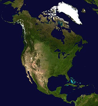
A full view of the sunlit side of Earth, showing North and Central America, taken by NASA's EPIC camera on the DSCOVR satellite in July 2015 from nearly one million miles away.

Where the Americas Are

The Americas are a very big piece of land. They are made up of North America and South America. Together, they are the second largest land area on Earth, after Asia. Many people call them the New World.

People often say the name "America" comes from Amerigo Vespucci, an explorer from Italy. You can learn more on the Naming of the Americas page.

Land and Nature

The Americas are very long, stretching from north to south. In the cold north, there is tundra in places like Greenland. In the warm south, there are tropical rainforests full of plants and animals.

Tall mountains called the Andes run along the west side of South America. The Amazon basin is a wide, flat area with a huge river that carries more water than any other river on Earth.

People Long Ago and Today

People first came to the Americas from Asia more than 20,000 years ago. Many groups of Indigenous peoples of the Americas built cities, grew food, and lived in strong communities. The Maya, Aztec, and Inca are some of these groups.

Later, people from other lands came to live here too. Today, more than a billion people live in the Americas. Many of them live in big cities like Greater Mexico City, São Paulo, and New York City.

Many people in the Americas enjoy sports. Baseball is very popular, and Football is loved by many fans across the region.

Quiz time!

3 questions about Americas

Question 1 of 3

Which two parts make up the Americas?

Pictures

The 1507 Waldseemüller map, the first map to use the name "America" and the first to show the Americas as separate from Asia.
A 17th-century print of Amerigo Vespucci, the Florentine explorer whose first name inspired the name "America."
A map showing how the Americas are divided into North America and South America.
A map showing how the Americas are divided into North America, Central America, South America, and the West Indies.
A map showing how the Americas are divided into North, Central, and South America.
A map showing how the Americas are often divided into Anglo-America and Latin America, based on the languages and cultural histories of each region.
The southern side of Temple 11, an ancient Maya building in the East Court of Copán, in Honduras.
A statue representing America, set in a niche on the Palazzo Ferreria in Valletta, Malta.
John Vanderlyn's painting shows Christopher Columbus landing on an island in the West Indies on October 12, 1492. He raises the royal banner of Spain, and the crew reacts in different ways, with some searching for gold in the sand.
A historical map showing how countries in the Americas gained their independence.
An aerial view of Aconcagua, the highest mountain in the Americas, located in the Andes of Argentina.
A colorful map showing the climate zones of North and South America, using the Köppen climate classification system to group areas by their typical temperature and rainfall patterns.
A view of the Reforma avenue skyline and the green trees of Chapultepec Park in Mexico City.
The Octávio Frias de Oliveira Bridge and the CENU business center in São Paulo, Brazil, seen in a city view.
flag of Saint Kitts and Nevis
Flag of the Bahamas
Flag of Saint Lucia
Flag of Saint Vincent and the Grenadines
Flag of Grenada
The flag of El Salvador.
Map of early human migrations based on the Out of Africa theory
Flag of Anguilla, adopted on 30 May 1990 and modified slightly on 25 January 1999.
The flag of Antigua and Barbuda
The flag of Argentina.
The flag of Aruba
flag of Barbados
The flag of Belize.
Flag of Bermuda
National flag of Bolivia Flag of Bolivia* countryTemplate:I18n/Republic of Bolivia used byBolivia from1851 untilPresent created byGovernment of Bolivia format15:22 shaperectangular coloursred, yellow, green flag has 3 horizontal stripes other characteristicsA horizontal tricolor of red, yellow and green.
Flag of Bonaire.
Flag of the British Virgin Islands
Flag of Canada introduced in 1965, using Pantone colours. This design replaced the Canadian Red Ensign design.
Government Ensign of the Cayman Islands.
It is easy to put a border around this flag image
The flag of Colombia.
Flag of Costa Rica
The flag of Cuba. Colors are from http://www.nacion.cult.cu/fr/sobrebandera.htm
The flag of Curaçao is a blue field with a horizontal yellow stripe slightly below the midline and two white, five-pointed stars in the canton. The geometry and colors are according to the description at Flags of the World.
The Flag of Dominica.
The flag of the Dominican Republic has a centered white cross that extends to the edges. This emblem is similar to the flag design and shows a bible, a cross of gold and 6 Dominican flags. There are branches of olive and palm around the shield and above on the ribbon is the motto "Dios,Patria!, Libertad" ("God, Country, Freedom") and to amiable freedom. The blue is said to stand for liberty, red for the fire and blood of the independence struggle and the white cross symbolized that God has not forgotten his people. "Republica Dominicana". The Dominican flag was designed by Juan Pablo Duarte, father of the national Independence of Dominican Republic. The first dominican flag was sewn by a young lady named Concepción Bona, who lived across the street of El Baluarte, monument where the patriots gathered to fight for the independence, the night of February 27th, 1844. Concepción Bona was helped by her first cousin María de Jesús Pina.
Flag of Ecuador
British flag of the Falkland Islands since 1948
Federal dependencies of Venezuela's Flag
Flag of French Guiana. Adopted as official flag by the General Council on January 29, 2010.
Flag of Greenland
Flag of the Regional Council of Guadeloupe.
The flag of Guatemala, official since 1871.
The flag of Guyana
The national and official state flag of Haiti; arms obtained from File:Coat of arms of Haiti.svg. The civil flag can be found at here.
The flag of Honduras
Flag of Jamaica. “The sunshine, the land is green, and the people are strong and bold” is the symbolism of the colours of the flag. GOLD represents the natural wealth and beauty of sunlight; GREEN represents hope and agricultural resources; BLACK represents the strength and creativity of the people. The original symbolism, however, was "Hardships there are, but the land is green, and the sun shineth", where BLACK represented the hardships being faced.
Flag of Martinique adopted on February 2, 2023
Flag of Mexico Official version of the Flag of the United Mexican States or Mexico, adopted September 16th 1968 by Decree (Published August 17th 1968), Ratio 4:7. The previous version of the flag displayed a slightly different Coat of Arms. It was redesigned to be even more resplendent due to the upcoming Mexico City 1968 Olympic Games; According to the Wikipedia article "Flag of Mexico", the colors are Green Pantone 3425 C and Red Pantone 186 C. According to [1] or [2], that translates to RGB 206, 17, 38 for the red, and RGB 0, 104, 71 for the green.
Flag of Montserrat.svg
The flag of Nicaragua
The flag of Panama
Flag of Paraguay (obverse).
Flag of Peru
Flag of Puerto Rico
Flag of Saba.svg
Local unofficial flag of Saint-Barthélemy, overseas collectivity of France
Unofficial flag of Saint-Pierre and Miquelon.
Flag of Sint Maarten (Kingdom of the Netherlands)
Flag of Sint Eustatius
Flag of South Georgia and the South Sandwich Islands.svg
The flag of Suriname
Flag of Trinidad and Tobago
Flag of the Turks and Caicos Islands
Flag of the United States Virgin Islands
Flag of Uruguay
The flag of Venezuela
New York City – largest urban area in the Americas, with a population of 18,351,295 in 2010

Keep exploring

This article is a child-friendly adaptation of the Wikipedia article on Americas, available under CC BY-SA 4.0.

Images from Wikimedia Commons. Tap any image to view credits and license.